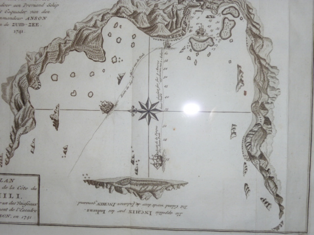
Plan d'une Baye de la Côte du Chili découverte par un des Vaisseaux d'Avituaillement de l"Escadre de Mr. Anson, en 1741.
ANSON
Referencia Librería:
ANSON1741
Idioma:
Francés
Antiguo
HOJA N. 14
Plano de una bahía de Chile con detalle de una isla llamada Inchin por los nativo Americanos. La circunnavegación de Anson, uno de los últimos viajes de bucaneros, fue acosada por dificultades. Sólo una embarcación de seis terminó el viaje. En aquel tiempo su flota alcanzó a la Isla Juan Fernández, el único santuario disponible para el barco inglés a lo largo de la costa occidental de Sudamérica bajo control español, dos terceras partes de su tripulación habían fallecido. 20,4 x 26,8 cm (image size). Plan of a bay in Chile with a detail of an island called Inchin by the native Americans. Cartographic elements include profiles of the coast, soundings, sea banks or shoals, compass rose, and scale. Anson's circumnavigation was beset by difficulties. Only one ship out of six finished the voyage. By the time his fleet reached Juan Fernandez Island, the only sanctuary available for the English ship along the Spanish controlled western coast of South America, two thirds of his crew had perished.
DIRECCIÓN:
Mestral 8, 17742, Avinyonet de Puigventós, Gerona (España)
| CIF: | 35052440A |
|---|---|
| Móvil: | 628208909 |
Condiciones de gastos y envíos
PAGO POR visa, mastercard, o transferencia bancaria. ENVIO POR MENSAJERIA EN ESPAÑA Y PARA PAQUETES NO MUY GRANDES. PRECIO DE ENVIO 7 EUROS EN CONDICIONES ESTANDARD. NO SE ACEPTAN DEVOLUCIONES EXCEPTO SI EL ARTICULO ESTA MAL DESCRITO.
TAMBIÉN PODRÍA ESTAR INTERESADO EN...
SELECCIONES UNILIBER
-
Quijotes + INFORMACIÓN

-
Arte + INFORMACIÓN

-
Gastronomía + INFORMACIÓN

-
Viajes + INFORMACIÓN
-
Infantiles y juveniles + INFORMACIÓN

-
Tebeos y Cómics + INFORMACIÓN

-
Teatro + INFORMACIÓN

-
Poesía + INFORMACIÓN

-
Cine + INFORMACIÓN
-
Música + INFORMACIÓN

-
Moda + INFORMACIÓN
-
Erótica + INFORMACIÓN
-
Tauromaquia + INFORMACIÓN
-
Biografías + INFORMACIÓN
-
Filosofía + INFORMACIÓN

-
Religión + INFORMACIÓN

-
Historia + INFORMACIÓN

-
Derecho + INFORMACIÓN
-
Ciencias + INFORMACIÓN
-
Medicina y Salud + INFORMACIÓN
 CONTACTO


