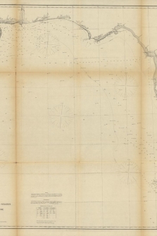
Gulf coast of the United States; Key West to Rio Grande.
AD Bache
Referencia Librería:
1863keywestNC
Editorial:
US Coast Survey
Año:
1863
Idioma:
English
Raro
Materias:
Viajes
This matched pair of maps covers the coastline from the mouth of the Rio Grande east to Key West. Western Part (23.0 x 28.1") extends from the Rio Grande to Terrebonne Bay in Louisiana. Along the way, Corpus Christi Bay, Matagorda Bay, Galveston Bay, Sabine Lake, and more are identified. Eastern Part (28.5 x 27.6") stretches from the mouth of the Mississippi River to Key West. Havana appears in the bottom right corner. Both sheets include many soundings, magnetic variation compass roses, notes, and table of abbreviations for bottom types with names of cities and islands along the coastline.
References:
Condition: B
Issued folding with light toning along the folds. There are separations at fold intersections with minor loss and along some of the folds, some of which have been closed on verso with archival materials. The first image is a composite image - the map is in two separate sheets.
DIRECCIÓN:
Mestral 8, 17742, Avinyonet de Puigventós, Gerona (España)
| CIF: | 35052440A |
|---|---|
| Móvil: | 628208909 |
Condiciones de gastos y envíos
PAGO POR visa, mastercard, o transferencia bancaria. ENVIO POR MENSAJERIA EN ESPAÑA Y PARA PAQUETES NO MUY GRANDES. PRECIO DE ENVIO 7 EUROS EN CONDICIONES ESTANDARD. NO SE ACEPTAN DEVOLUCIONES EXCEPTO SI EL ARTICULO ESTA MAL DESCRITO.
IMÁGENES DEL PRODUCTO
TAMBIÉN PODRÍA ESTAR INTERESADO EN...
SELECCIONES UNILIBER
- Quijotes + INFORMACIÓN
- Arte + INFORMACIÓN
- Gastronomía + INFORMACIÓN
- Viajes + INFORMACIÓN
- Infantiles y juveniles + INFORMACIÓN
- Tebeos y Cómics + INFORMACIÓN
- Teatro + INFORMACIÓN
- Poesía + INFORMACIÓN
- Cine + INFORMACIÓN
- Música + INFORMACIÓN
- Moda + INFORMACIÓN
- Erótica + INFORMACIÓN
- Tauromaquia + INFORMACIÓN
- Biografías + INFORMACIÓN
- Filosofía + INFORMACIÓN
- Religión + INFORMACIÓN
- Historia + INFORMACIÓN
- Derecho + INFORMACIÓN
- Ciencias + INFORMACIÓN
- Medicina y Salud + INFORMACIÓN


